top of page

Donjek Glacier hike
the adventure of a lifetime (so far)
GALLERY
 Burwash Creek stream crossingLaurence's turn. This is much harder than it looks with very fast water streaming away the gravel under your feet and boulders smashing your shins as they get carried by the stream. |  Changing back into hiking bootsThat's was freezing cold glacier run-off water. |  End of Burwash Creek mining roadTime to start bushwhacking! |
|---|---|---|
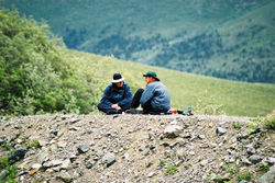
 Burwash Creek break timeThis is next to a century old prospector's cabin. |  Burwash CreekResting on the Taiga - mounds of small grassy knolls. |  Crossing the Burwash Uplands TaigaTraversing many kilometers of ankle-breaking tufa mounds of grass. |
 Cold morning on Burwash CreekCooking breakfast while trying to warm up. |  Kluane Park boundaryCreek beds comprised half the route. Here we finally approach the park boundary well into our 2nd day! |  Finally inside Kluane ParkFirst and last day of hike is actually outside of the park proper. |
 Up Burwash Creek to Hoge PassCarefully watching our steps; we're about 100 feet above the creek bed here navigating sheep trails. |  Two sheepThey like to watch... and laugh. |  Break time in Hoge PassFresh snow on shin deep mud. Slow progress as usual. |
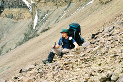
 Filtering water on Hoge CreekThe water was very tasty! |  Descending Hoge CreekA classic alluvial fan which is obvious to the geologically inclined. |  Adjusting heavy packNice laundry airing out there. |
 First glance of Donjek GlacierA very awesome sight. |  Steep climb out of Donjek River bedMostly we were either climbing or descending. Both are hard on the knees. |  Lunch along Donjek River tributaryDrying out some gear during a rare break in the rain that day. |
 It rained oftenWe got sun and rain and rain and sun. |  Donjek River valleyNot much of a trail to be seen. More tough slogging ahead. |  Double rainbow over Donjek GlacierWhen the rain moved out, we got beautiful rainbows. The vistas were amazing. |
 Donjek River valleyMosquito central! We were eaten alive here and quickly moved inside the tent. |  Wolf scatLittle bones were prevalent in wolf dung. |  Donjek Glacier toe (150+ feet)Laurence composed this amazing shot. |
 Toe of Donjek GlacierThis was the first time I saw a glacier up close in the deep wilds of Canada. |  Crossing Chert CreekNevermind that the water was ice-cold and our lower legs were numb. This was a shin-basher. Boulders were crashing down the stream into our legs. Ouch. |  Crossing Chert CreekHere you can get an idea of how fast the water was flowing. That is some fast dirty glacial water. Look at it cascading over the rock in the foreground. |
 Looking ahead on Chert CreekThe easy ascent side of Atlas Pass lies ahead. |  Three amigosA timer shot of the three of us at one of the most spectacular vistas. We had just ascended all the way up from the river bed you can see in the far-off distance. |  Huge wolverine!The little brown dot in the middle is not a rock. It's a wolverine taken with a huge telephoto lens. We were concerned that it would raid our campsite that night. |
 Camping in the high alpineNow that's what I call a room with view. |  Traversing iceTrekking poles were hugely helpful. |  Very steep scree slope in Atlas PassYou can barely make out part of our trail in the scree. |
 Break time in Atlas PassThis was the mountaineering part - two km of steep scree slopes - every step was scary. Here Laurence takes a well deserved break. |  Dinner break after descendingOur fourth meal that day and we were ready for it after a long descent out of Atlas Pass. |  Dinner break after descendingThis was a very steep descent; hard on the quads and toes. |
 Sheep skull with horns & furRecently enjoyed by bear or wolf. |  Sheep on steep rock face along riverIt climbed up a sheer rock face. We were sure it would slip and fall to its death but it didn't. |  Bushwhacking through the Taiga brushThere is no trail! |
 Precarious tent site: Granite CreekThe only flat spot we could find. |  Part of Donjek Glacier toeThe toe of the glacier is ~15km long. |  Donjek River ValleyA panorama of our approach to the glacier. |
bottom of page